Hudhufushi Lagoon Forum
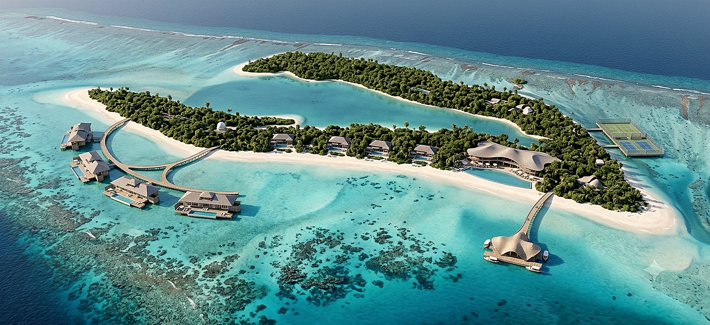
A 65-hectare island shaped like an open V — two long vegetated arms holding a protected inner lagoon. The geometry of the island writes the masterplan: 52 keys on almost four kilometres of shoreline, gathered around one thin roof, The Lagoon Forum.
The island was the first architect. Hudhufushi's two arms and its sheltered inner lagoon set the plan before we drew a line.
Hudhufushi is one of the largest islands of Lhaviyani (Faadhippolhu) Atoll designated for resort development — roughly 120 km north of Malé, a 35–40 minute seaplane from Velana International, in the resort ring around Innahura, Nala and Jawakara. Its form is rare in the Maldives: not a dot of sand, but an open V of vegetation whose arms shelter a lagoon of sandbanks and reef shallows. The design keeps that form intact. Buildings stand behind the vegetation line, the reef stays the first line of coastal defence, and most of the island's 65 hectares remain exactly what they are today — green.
| Location | Hudhufushi, Lhaviyani (Faadhippolhu) Atoll, Maldives |
|---|---|
| Coordinates | ~5°20′N 73°30′E · ~120 km N of Malé · 35–40 min seaplane |
| Island | ~65 ha · V-shaped · two vegetated arms · protected inner lagoon |
| Programme | 52 keys — 40 beach villas · 12 overwater villas · The Lagoon Forum · spa · observatory |
| Density | ≈0.8 keys per hectare — the greater part of the island stays untouched |
| Status | Island designated for resort development (Ministry of Tourism) |
| Stage | Self-initiated design study — architecture, structure, MEP, BIM |
The masterplan, in motion.
The overwater loop, the Lagoon Forum at the hinge of the island, beach villas held behind the trees — read against reef, sandbank and open water.
One island, two temperaments.
§03 — Masterplan strategyEach arm of the V becomes a different way of staying; the lagoon between them belongs to everyone.
Guests arrive by a single pier where the two arms meet, pass through The Lagoon Forum, and choose a direction. Nothing on the island is taller than the palms; nothing is louder than the reef at low tide. The 52 keys are read from the plan itself — 40 beach villas along the best frontages of both arms, and 12 overwater villas on one curved loop in the lagoon, large, far apart and deliberately few.
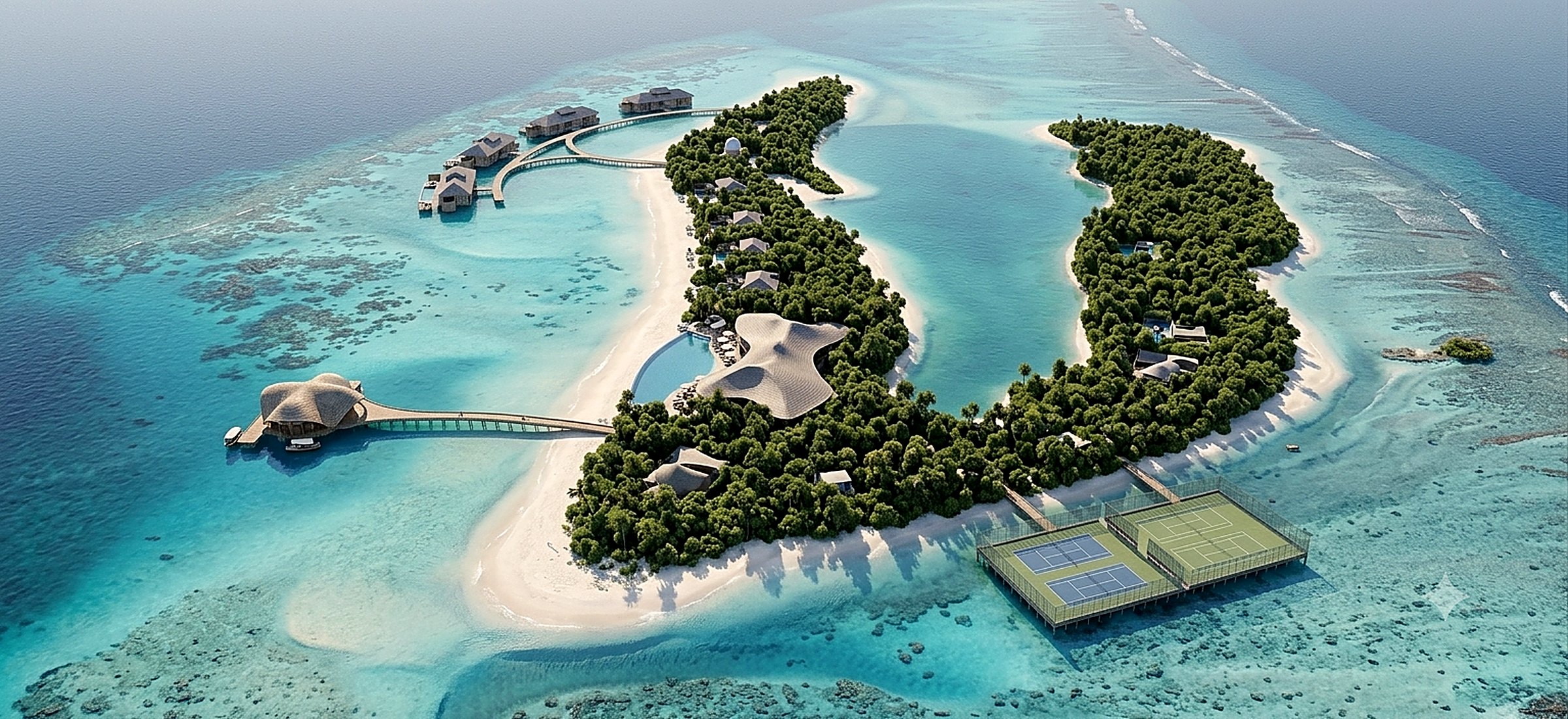
The quiet arm — wellness
Spa and wellness pavilions dissolved into the densest vegetation, adults-quiet beach villas, and an observatory deep in the green where the island's dark-sky lighting keeps the night genuinely dark. Paths run under canopy; there are no vehicles, only shade.
The active arm — beach & family
Family beach villas, the beach club and water-sports centre on the outer beach, and tennis and padel courts held on a screened platform off the eastern shore — sport kept audible to no one's veranda.
The inner lagoon — the heart
Twelve overwater villas on a single curved loop, generous and rare rather than crowded. Seagrass beds and coral heads are mapped before a single pile is positioned; the loop threads between them, not over them.
Arrival & The Lagoon Forum
A straight arrival pier meets the island at the hinge of the V. Arrival lounge, dining, bar and the long main pool sit under one floating roof, facing the calmest water on the island.
The working island
Back-of-house, desalination, wastewater treatment and the solar field are grouped on the least visible edge, screened by vegetation retained for exactly that purpose. Service routes never cross a guest path at grade.
The Lagoon Forum.
§04 — The iconic pieceOne thin roof, held at the hinge of the island — the point from which both arms, and both moods, can be read.
The Lagoon Forum gathers arrival, dining, lounge and the main pool into a single ensemble at the centre of the V. Its roof is deliberately thin — a floating plane with deep timber overhangs that carry the shade out over the decks; beneath it, stone plinths take the weather and the wear, and a long, calm pool lies flush with the lagoon horizon. It is the social condenser of the resort and its compass: from its shade a guest sees the quiet arm to one side, the active arm to the other, and the overwater loop across the water.
It is iconic through placement and proportion, not gesture. Every span, joint and overhang is sized for the trades, barges and logistics a remote atoll actually has — a roof that photographs like a landmark and builds like a pavilion.
Designed with the reef, not just beside it.
§05 — Architecture · engineering · ecologyPremium through space, shade and proportion
Low volumes behind the vegetation line, deep verandas, and a palette of timber, stone and lime render left to weather into the island's own greys and browns. Luxury is measured here in metres of privacy and hours of shade, not in ornament.
Light on the land, lighter on the lagoon
Prefabricated, transportable framing sized for barge logistics and corrosion-aware in every detail. Villas are micro-sited between existing trees; the overwater loop repeats an efficient span on the fewest piles the structure allows, coordinated with the marine and geotechnical specialists who own the lagoon works.
The reef is the first infrastructure
The reef and the retained vegetation are treated as the island's primary coastal protection — everything else is designed around them. Solar with battery storage, desalination with energy recovery, wastewater treated and reused for irrigation, no groundwater draw, and dark-sky lighting that protects nesting turtles, the reef at night and the observatory's sky alike.
Model-based, buildable, measured
A federated BIM model with Tekla detailing and fabrication-level drawings — fewer barge trips, less material waste, and quantities known before they are shipped. Construction is staged from disturbed ground outward, so the untouched parts of the island stay untouched.
Two arms, one lagoon.
From the east, the plan explains itself — the quiet arm, the active arm, and the water they both protect.
The island is shaped like a V. The masterplan simply agrees.
Hudhufushi is why this study exists: a real island whose scale and geometry reward exactly the disciplines we practise — masterplanning that follows the land, structures light enough for a lagoon, and documentation precise enough to build far offshore. This is a self-initiated design study of that island, not a commissioned or built project.
If Hudhufushi — or any Maldives island — became a live project, we would work as the technical partner alongside the Maldives-registered consultants who carry local responsibility: the architect of record, structural checkers, MEP and utilities engineers, and the EIA, coastal and marine specialists responsible for foundations, lagoon works and environmental approvals. Our role is design, structural engineering, MEP coordination, BIM and construction-oriented documentation.